I think when you read an online trip report (I) can get drawn in by the images and then it floats around in my mind until I get the opportunity to experience it for myself. On paper its (only) a 70 mile route, with around 4000m of ascent and a suggested itinerary of doing it over 3 days. But as we were to find out, it was so much more than the simple statistics.


It was slightly fraught (for me) trying to remotely pin down the exact time to try it with interested parties in different parts of the continent, but a 'conference' call with Shaw and Judith meant we all agreed to give it a go with an immediate window on the horizon.


We met at Bourg-Saint-Pierre in Switzerland at a cool little campsite. I was surprised how chilly it was, but I guess it is in the mountains, and a big change from the heat of mid France. Shaw, Judith and I headed up to the Great St Bernard Pass, which is on the route to do a wee acclimation walk the day before we started the ride.


Day 1 - After plenty of faffing, we disembarked, not entirely knowing what to expect, but all in high spirits. The route crosses 3 x high passes, and the first days was the Great St Bernard Pass (2469m). We started on nice quiet roads, then there was a lovely long stretch alongside a big hydro lake before we joined the main road to the pass. I kind of thought that this would be easy, but it was actually tougher than expected, but the main hassle was the over taking traffic. Eventually we reached the pass and had lunch, cup of tea and surveyed the scene before heading into Italy.


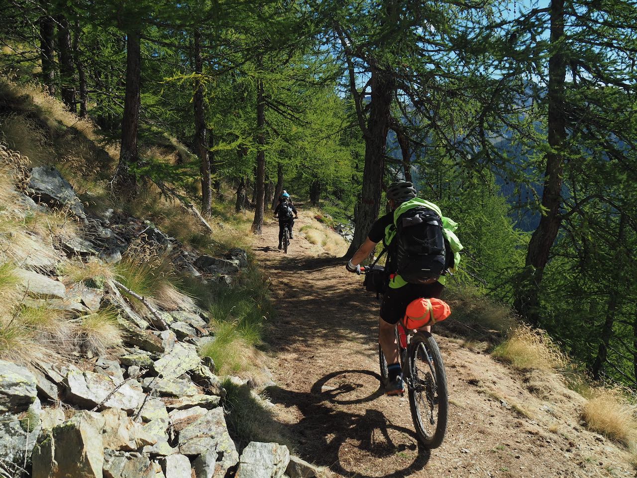
After the initial descent into Italy on great trails that kept crossing the road hairpins the route headed off on an amazing high balcony trail that seemed to go on for hours. I was fascinated that we didn't see another soul on this section as the track was so good. It was jaw dropping with views of the mountains all around. After the seemingly endless traverse we encountered a really tough hike a bike section. Sitting typing this I now think that maybe it wasn't too long, but at the time it was really challenging and we had to work together to get the laden bikes though this section, up rooty steps, under a fallen tree, up a ravine!


Bizarrely, when we got beyond this and dropped down to another good track section there was an ebike solar charge station and an old war defensive tunnel system to explore! We were yet again on nice trails. I had looked at the route and sort of ear marked a couple of points that it would be nice to get to by the end of the day, but we didn't get as far as we thought and stopped on some sloping ground near alpine pasture with accessible water as we were all pretty tired.


Day 2 - We awoke to a surprise as the farmer was taking his cows out to pasture as we were packing up camp. He waved as the inquisitive cows came past us. We were relieved that we weren't camped lower down or we would have been really in the thick of the herd!

After a short bit of uphill again we had more amazing balcony trails, mainly to ourselves, but we passed a couple of hunters, a jogger and a few small farms. It was incredibly rural with cows being milked by individual machines into traditional metal churns then these would be taken down the mountain dirt roads by pickup truck!


Eventually we got to a parking trail head where we could see the Fenetre de Durand Pass (2,797m) in the distance. This is the high point of the whole ride and we gazed across to it, all knowing that this day would be the toughest of the trip. Again we followed an endless balcony path which was also the route of an ancient water transport route. This was another really cool section of trail, gradually dropping height with a small section of cave to get the bikes through!

The heat got to me at the start of the climb, I was knackered after a seemingly long day, but now faced with the actual real climb. But nothing to do but press on. We all settled into our own worlds I think to just get through this next bit! The initial dirt track was rideable, but after riding all day I was 'gubbed' and spent a lot of time pushing up hill. A the end of the rideable push track there was a lot more pushing/ carrying and we all were literally 'pushed' to our limits. Shaw and Judith carried their bikes on their back, I couldn't lift my laden bike! We passed through an interesting giant boulder section before the pass that looked like it would have world class bouldering if anyone could be bothered (ebike would ease the pain). Finally we reached the pass around 6pm and the views were incredible. What a place!

It was a shame we couldn't spend longer on the pass, but we were all aware that we had to drop a lot of height and find somewhere to camp before it got dark in 2 hours time! We didn't know how rideable the trail would be but it was pretty amazing single track! Kev discovered an issue with one of his brakes so this slightly curtailed some of the descent for him.

We found a nice camp spot still fairly high (maybe 2000m) and settled in for a nice but chilly night. After camp duties I slept well until the chilly morning. Our camp looked out to mountains and glaciers and to the left we could see the lake our trail took us to.

Day 3 - Judith felt quite ill in the morning, but again we all packed up pretty quickly and headed off. The remaining descent to the Lake level was epic! I rode stuff I probably shouldn't have done, but I was having the time of my life on this trail.
When we got to near the Lake we saw a large group of ?farmers and helpers heading up the rough ground, we guessed to bring the herd down for the winter.

Along the Lake shore we went, now on a dirt road, before popping into a really crazy tunnel system which went on for a few miles (well, over a mile I'm sure), it had some lighting and occasional cut out windows to see the view! There were signs that the tunnel gets locked in the winter, and only local farmers are able to take vehicles up through it. We saw plenty of ebikes heading up as we shot down before it spat us out onto the enormous dam wall!!! We surmised that it was probably a condition of building the dam/blocking off the whole valley that they had to create a road up the valley, but what an incredible feat of engineering!

We continued to drop like a stone! Judith was really suffering at this point as Kev and I joined them at a small settlement and sadly the decision was made that we had to rethink the route. After considering possible options we decided to split up. Judith and Shaw were to continue down to a larger village and see how Judith was, Kev and I decided to carry on. We toyed with dropping down too, and waiting until the next day to see how everyone felt, but when we looked at the heights, we felt that we probably just wouldn't come back up to continue the route from such a low altitude.

I felt pretty gutted that we split up at this stage, but also thought it the right thing to do. As we couldn't find a shop for extra food and we were only carrying supplies to finish on this day, Kev and I went to a bistro and had a 'slap up' meal before we carried on. After (only) a couple of days on the trail the lasagne and green salad was like a dish sent from the gods...

On we went, initially on easy, gently rising roads, which became dirt roads, which became tricky single track. On, and on we went. I spotted a high barn on the hill and knew we'd end up passing it... it took forever to get to it, but we had 15 minutes rest eating salami and clif bars to power us up the final climb and to the final col.
During the last hour or so to the col again I felt pretty done! Pushing on we finally arrived at the col and it felt great and we could see the finish miles (and miles) away. Again time was pressing on so we only had 10 mins rest before shooting down an amazing descent track.
I/we thought that the route was in the bag and toyed with making a cup of tea in the glorious early evening light. Thank goodness we didn't as it wasn't over! We had another few miles of uphill (argh), then a really awful sting in the tail, unridable track that was going downhill, but impossible... I'd slightly had enough by this point...
What next? Well another lovely traversing track that eventually passed a barn/farm building. At this point we saw that our GPS track continued uphill before a steep forest descent. But we were at a cross roads with dirt tracks that started to head down to the start at Bourg-Saint-Pierre.
We headed down, dropping hundreds of meters on fast dirt roads before hitting the forest. We then followed our noses on steep but fun forest tracks which deposited us back in Bourg! What a ride. We arrived back and Shaw and Judith were already at the campsite. It was nice to be reunited and they kindly made us a cup of tea as we collapsed at camp. We weren't expecting to see them at camp, and they weren't expecting us to make it until the next day! Shaw had left Judith recuperating in a village and cycled a massive lower loop back round to the start to grab their vehicle and go and get her. I hear he managed to get a burger and chips enroute (good effort!).
It was sad that we didn't all finish the route together, but I definitely feel that the experience was really positive for all of us. We all pulled together as a team and I thoroughly enjoyed the whole experience. It has certainly left an impression on me, with lots of great memories. The evening after finishing Judith cooked us a great meal before we all went our separate ways the following day.
Just need to find another adventure for next year!